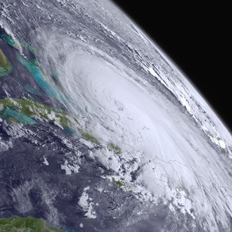
Hurricane Joaquin got bumped up Thursday to a Category 4 storm, and walloped the Bahamas with more than 120 mph winds, crushing surf, and rain. The warm Caribbean waters are fueling the system, strengthening the storm before it leaves the area. Now everyone up and down the Eastern seaboard is stressing about where Joaquin’s headed next.
Right now, it’s just way, way too early to tell, says New York Metro Weather meteorologist John Homenuk. The models that track the storm keep shifting — and they will probably keep going haywire overnight and into the next day, though the latest models seem to show Joaquin getting pulled east, out to sea. “There’s a lot of uncertainty right now,” Homenuk says. “The storm is still a couple of days away, and as we’ve seen from the last few days, they have made adjustments — wild adjustments every day. It would be really irresponsible to rule anything out at this point.” With that in mind, Daily Intelligencer pressed Homenuk on the question of whether we should still stock up on bottled water and batteries.
What does it mean that Hurricane Joaquin has been upgraded to a Category 4?
It’s a pretty impressive storm. The water where it is right now is very, very warm. The heat content in the water and the atmospheric setup is very, very good for the storm to strengthen. The storm is probably, over the next 12 to 24 hours, going to hit a point where it’s the strongest it’s going to be. But again, the models are adjusting as we speak.
Why does the forecasting seem so chaotic? Is this storm harder than usual to predict?
There are a lot of different forecast models, and a lot of forecast models are shifting all over the place. The situation that would cause the storm to get pulled back toward the U.S. East Coast is very anomalous: There’s another disturbance that’s coming in over the southeastern states, and that is going to swing down and try to tug at the storm, trying to keep it close to the coast. But there’s also another disturbance out in the central Atlantic that’s trying to pull the storm out to sea. So it’s kind of caught in between both.
Which one is going to win?
What the models are really struggling with is: Once Joaquin leaves the Bahamas area, what is it going to be more heavily influenced by? Is it going to be tugged to the east or is it going to come back west? Little intricate details, in terms of where the storm is, where those other two disturbances are, are just causing the models to be in havoc. The real narrative is the European model has been showing the storm going out to sea for a couple of days now, and all the American models today seem to be adjusting to that situation. That’s something we need to keep an eye on.
That’s the best-case scenario — that it gets pulled out to sea?
That’s definitely the best-case scenario in terms of avoiding impact. There would still be some high surf and some rain. But even if the storm were to phase and come into the coast further south in the mid-Atlantic, we would still see some pretty significant impacts here. There would be a very strong on-shore flow, there would probably be coastal flooding. It wouldn’t be pretty.
So right now it doesn’t seem like it will be making a direct hit to New York?
That’s fair to say. Last night we had a little scare. One forecast model decided to bring a storm right into New Jersey. But, as of right now, we don’t have anything showing that.
Is this weird, constantly cloudy and rainy weather related at all?
We went into a little bit more of an unsettled pattern, but it’s not directly related to the tropical storm.
So it would be Sunday into Monday that we would feel any effects, or could that shift too, depending on how the storm tracks?
There’s a frontal boundary this weekend that’s going to be early Friday into Saturday that’s going to be bringing on-shore flow into the area, so we could see some rain and some wind on the coast. But that’ll be intermittent; it’s not going to be a total washout. But the wind and the on-shore flow off the ocean is already bringing tidal flooding to some areas. I saw a picture out of Manasquan [New Jersey] and there’s already flooding there. That could continue through the weekend with the unsettled weather and then following that it kind of depends on the exact track of the storm. The tropical storm impacts would come Sunday into Monday — if the storm were to come back toward the coast.
And any sense when it will be sunny again after all this?
If the storm moves and doesn’t come up the coast we could see some sun this weekend, and early next week things will be okay. So much of the forecast depends on the track of the storm, and so much of the track of the storm depends on what happens in the next day or so. So we’re kind of in a holding pattern.
This interview has been edited and condensed.


