New York City is having an icy breakup with its warm winter this Valentine’s weekend. The northeastern United States will likely see the most bone-chilling temperatures of the season so far as a result of the dreaded “polar vortex” effect.
New York and New England will get close to record-breaking low temperatures, along with some bitterly cold winds. The good news is that the weather should be back to or slightly above the seasonal norm by the middle of the week. Daily Intelligencer asked New York Metro Weather meteorologist John Homenuk to give us a brief science lesson and do some expectation-setting for what looks to be a historically cold weekend. “It’s going to be brutal, and it’s going to be short-lived,” he sums up. “We’re New Yorkers — we’re going to get through it.
So, what’s going on?
There’s a large ridge on the West Coast, up into western Canada and up into the Arctic. When that occurs, the circulation over the Arctic, which typically is pretty strong, gets disrupted. Pieces of the polar vortex — not necessarily the polar vortex itself, but modified parts of it — can pinch off and move around.
What’s happening this weekend is a pretty large trough is breaking off from where it typically exists, which is up in the Arctic, and it’s dropping all the way down through Canada toward the northeast United States. So the good news is that it’s transitional. It’s not something that’s going to stay locked in because we don’t have any blocking to the north to keep it there. It’s going to swing through and swing out. The bad news is that it’s very, very anomalous. It’s very cold, and it’s going to be pretty brutal when you factor in the winds.
Why is it going to be so windy?
It’s all part of one thing. The wind kind of maneuvers the air masses. This is a quick-moving air mass. They’re coming out of a very cold source region. So we’re getting air from Canada, and the air mass can be traced all the way back to the Arctic. Obviously it modifies a little bit by the time it gets here. But it is an Arctic air mass.
Can you tell me a little more about this ridge that apparently pushed a chunk of polar vortex our way?
As you’ve noticed, we’ve had all these storm threats recently. That’s because we’ve had this ridge on the West Coast. All the energy that’s coming out of the Pacific Ocean goes over the top of that ridge, kind of like a roller coaster, and then comes down into the eastern United States. That ridge has been a dominant feature over the last couple of weeks, and it’s been a matter of time before we got this shot of very cold air. We’ve kind of been waiting for it.
So are we going to break any records this weekend?
It’s going to be close. The record low in New York City for Sunday is two degrees; I think we’re going to be real close to that. It’s really hard for New York City to get below zero now. You need perfect conditions. There’s so much activity there [in the city that] you get this localized urban heat. Even on the coldest nights, New York is always a little warmer than the suburbs. I would think in the suburbs — possibly even places like Newark and La Guardia — there will be records broken.
Like below zero?
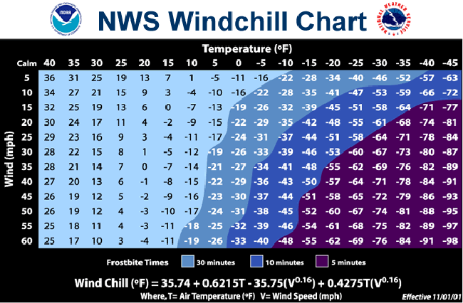
Single digits, and I think we’re going to flirt with zero. But, you know, the real killer is going to be the windchill. So when you talk about temperatures near zero and you get winds 20, 30 miles per hour, the windchill could feel like negative 20 outside on Sunday. And that’s crazy cold.
Ahhhah.
Yeah, it’s going to be pretty brutal. It will probably be pretty worse farther north. In New England, they’re expecting below-zero temperatures and stronger wind gusts. But even in the city, -10 or -20 is nothing to mess around with.
Go watch Netflix, and don’t go skiing.
Fire up the Netflix, for sure.
But once Sunday is over we’ll pretty much see normal temperatures again?
It will linger into Monday; it will probably still be pretty cold. But models actually show that big trough moving out fairly quickly to the point that we have a storm system that could amplify and give us rain on Tuesday. That’s pretty crazy. That system is still uncertain currently, but most of the models are showing temperatures warming up.