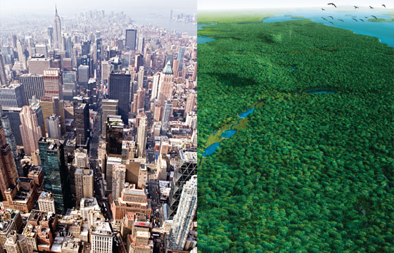
For the last 400 years, since Henry Hudson arrived on these shores, Manhattan has been a place where people have seen what they wanted to see, and then remade it in that image. It’s been a Rauschenberg canvas, built out, cut away, layered thick with new visions, with little thought to what was there before, after which the new visions are torn away themselves. But before the towers and brownstones, before the street grid and infill, before Bloomingdale Road, before Broadway, before the farms, before the British, before the Dutch, before Henry Hudson himself, was a place called Mannahatta, island of many hills. New research by Eric W. Sanderson, a landscape ecologist at the Wildlife Conservation Society, based at the Bronx Zoo, augmented by digital re-creations by Markley Boyer—their work is the basis of an exhibition at the Museum of the City of New York opening May 20 and a new book, Mannahatta, published by Abrams next month—has opened a window onto what New York City was like before Europeans arrived. The window has remarkable resolution—the height of the hills, the species of trees, the wandering paths of the creeks—geo-referenced to the current street grid.
Mannahatta was occupied by the Lenape—the “real people,” the most venerable of the Algonquin groups. Mannahatta was, essentially, their summer place—the Hamptons to the Lenape longhouses in the Bronx and possibly points north. It was both a hunting ground and, amazingly, a rich fishing camp, with shad, bass, sturgeon, and oysters. Their empty shells accumulated in mountainous piles called middens. Analysis of their cooking fires has shown that grains and legumes were secondary in their diet to seafood. The biggest settlement was in Inwood. The downtown community was centered on what is now Foley Square, near a large pond. In the West Village was a fishing camp, a stream known as Minetta wandered past Washington Square Park along the course of Minetta Street, thence through Sapokanikan, now called the West Village—where tobacco was grown, according to Dutch reports—and into the Hudson at Charlton Street.
Henry Hudson’s main imagining was of a passage to the east. So when he anchored the Half Moon—his gaily painted, 85-foot ship—off the island in September 1609, he saw Manhattan in nautical terms: It was “very abundant in all kinds of timber suitable for ship-building,” according to the ship’s log. He also made note of the Lenape’s impressive copper tobacco pipes. (The Lenape are said to have believed his ship to have been “a large house of various colors.”)
Hudson’s crew did not manage to take the full measure of the island they had found. But for the Lenape, the appeal of Mannahatta was in the diversity of its ecosystems. There were more ecological communities per acre than Yellowstone, more native plant species per acre than Yosemite—30 kinds of orchids, for instance. There were also 230 types of birds, nearly 80 kinds of fish, plus bears, wolves, beavers, otters, and numerous others. By contrast, there were no starlings—they were introduced to Central Park near the end of the nineteenth century—and possibly no Canadian geese. Supporting this richness were 66 miles of streams, 21 ponds, and 300 springs, fed by water stored in the underlying sand and gravel pushed here by the glaciers that shaped Mannahatta some 14,000 years ago. On Mannahatta, as elsewhere in the eastern forests, the Lenape modified the environment, too, by burning, to clear land for travel and, more important, to create better ecosystems for hunting—East Harlem was a meadowed, savannalike expanse created by regular burning that was likely a favored hunting ground. Click for a PDF of a map of this lost world.
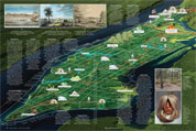
Open the PDF: New York Before the Europeans Arrived
Adapted from Mannahatta: A Natural History of New York City
(Abrams)
By Eric W. Sanderson
Illustrations by Markley Boyer